
Georgia Geo’s Aerial Assets define
Efficiency, Performance, and Reliability.
Georgia GEO LLC uses advanced long-duration aerial platforms boasting rapid and efficient data collection capabilities and unsurpassed time-on-target.
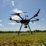
Our preeminent asset, the DJI Matrice 600 PRO, features flight durations of 40 minutes (or more)! In that time, we can cover more than 200 acres or stream TV broadcast-quality, time-critical video information to Emergency Management Agencies.
In the performance of aerial inspections, the M600’s A3 Flight Controller allows Georgia GEO to precisely maneuver and thoroughly examine infrastructure emplacements, construction sites, or areas suffering the effects of a natural disaster.
The Matrice 600 PRO is the workhorse which can provide the ultimate in mission capability for demanding customers.
Georgia GEO‘s Aerial Camera systems
SlantRange 3p
Unsurpassed Multispectral Imagery processed immediately at the edge of the field. No cell or other wireless network needed. No waiting on some far-off cloud imagery processing. This multispectral imagery provides metrics regarding the size, health, and yield potential of crops to growers, agronomists, and clinicians.
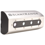
UASWeekly.com says: “SlantView is already proven as an invaluable tool for agriculture with its powerful offline analytics and efficient workflows…across all of the world’s agricultural acres.” The lower costs of data collection, processing, and information can accrue to even the smallest farmers…and the SlantRange 3p delivers on that promise.”
Immediate, actionable data.
Information which cannot be captured by satellites, manned aircraft, or ground-based systems is being provided by the SlantRange 3p, delivering on a technology which requires innovation.
Crop data must be accurate, and trusted. Important vegetation signals must be separated from the background clutter and adjusted on-the-fly for changing environmental conditions. This is the sytem which does it.
ONLY Georgia GEO offers this technology to the Middle Georgia grower!
Georgia GEO and SlantRange are addressing farmers’ challenges through technical innovation in remote sensing hardware systems, visionary computer application, artificial intelligence analytics, and the network architectures for how data is collected, processed, and distributed.
Zenmuse X5
Georgia GEO currently flies the DJI Zenmuse X5 Aerial Camera system, mounted on a 3-axis gimbal, capturing imagery in crisp, stunning clarity for Construction site or Infrastructure inspections. The Zenmuse X5 captures still imagery at 16 MP, records 4K video at up to 30 fps, and is capable of transmitting high frame rate, HD live streaming to professional broadcasters.
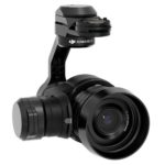 Georgia GEO proudly offers the X5 to capture imagery for clients who demand excellence. Welcome to the future of aerial imaging.
Your crop is trying to show you something…..we help you see it